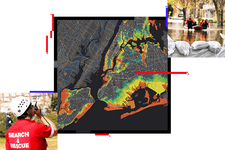
Geographic Information Systems (GIS) have become one of the most important technologies in disaster management because disasters are deeply linked to location, movement, infrastructure, and population exposure. Floods, earthquakes, landslides, storms, wildfires, industrial accidents, and other emergencies do not affect all places equally, so decision-makers need a system that shows exactly where risks exist, which communities are most vulnerable, and what resources are available nearby. GIS makes this possible by bringing together maps, satellite imagery, road networks, elevation, land use, weather information, public facilities, and population data into one analytical environment. Emergency managers use GIS to identify hazard-prone zones, understand patterns of vulnerability, and design preparedness strategies before a disaster even occurs. This includes mapping evacuation routes, locating shelters, identifying hospitals and emergency service points, and estimating which populations may need priority support such as children, older people, or people living in high-risk settlements. Authoritative emergency management guidance emphasizes that GIS helps highlight areas of risk and vulnerability by combining hazard, infrastructure, and demographic information, while operational users increasingly rely on real-time GIS for situational awareness and response coordination.
During a disaster, GIS becomes even more valuable because it allows responders to visualize conditions as they change. Flood extent, blocked roads, damaged bridges, affected buildings, fire spread, disrupted lifelines, and the movement of emergency teams can all be monitored and shared on maps and dashboards. This creates a common operational picture, which improves coordination between government departments, humanitarian organizations, rescue teams, and field staff. Instead of depending only on text updates or disconnected field reports, agencies can see the spatial reality of the crisis and make faster, more informed decisions about where to send rescue teams, how to route relief supplies, and which areas need immediate attention. Emergency management organizations describe GIS as central to resilience, response, and recovery because it strengthens situational awareness, damage assessment, and public information sharing.
After the disaster, GIS supports recovery and long-term risk reduction. It helps assess physical damage, estimate affected populations, prioritize restoration of roads, electricity, water networks, schools, and health facilities, and identify locations that remain exposed to future risk. GIS-based risk maps are also widely used in flood and hazard assessment research to support safer planning and mitigation decisions. Over time, this allows planners and policymakers to rebuild more intelligently, strengthen resilience, and reduce the impact of future disasters. In this way, GIS is not only a mapping tool but a full decision-support system that improves preparedness, response speed, coordination, recovery planning, and long-term resilience.